Great Circle Maps
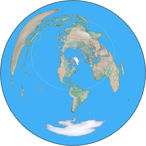
On a great circle map, a straight line from the center of the map to any other point on the earth lies along the great circle path to that point, which happens to be the path followed, usually, by radio waves.
SkookumLogger has two map display windows. The Great Circle Map window shows an image that includes all of the earth:

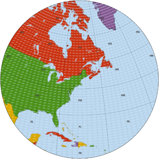
The Maidenhead Map window shows a circular segment of the full-earth projection with embedded grid lines and Maidenhead labels, like this:

The maps are contained in image files. You need a separate image file for each kind of map that you want to use.
These maps are only useful when they are centered near your location. This web page has a selection of links to maps for different locations. To use a map in SkookumLogger, download it to your computer, show the appropriate map window, then use the appropriate Windows ▶ Maps ▶ Change Great Circle Map or Windows ▶ Maps ▶ Change Maidenhead Map command to load the image file.
The map names in the lists below use the call of the requester or a name for the general geographic area. The Maidenhead locator for the map center coordinates is shown in parentheses. The names are ordered by locator in the lists to help you find a map near your location. For Great Circle Maps, matching the first four characters of the locator is close enough. For Maidenhead Maps, you might want to match the first six characters of the locator.
Contact me with your geographic coordinates or Maidenhead locator if you need a map added to this page. For Maidenhead maps, also include the span of the map from bottom to top along the vertical diagonal through the center, in degrees. The span of the example map above is 60°.
Great Circle Maps
- KH6CW (BK29ao)
- Kenai Alaska (BP40ln)
- K6DF (CM87xn)
- K6DF (CM89oa)
- VA7NMD (CN79mq)
- VA7OTC (CN88hk)
- VA7GI Remote (CN79vl10)
- K6NYB (DM04lt)
- KB7XL (DM08)
- K7GQ (DM09cm)
- KJ6RVK (DM13cp)
- W1NV (DM79mm)
- WD7K (DN08wl)
- N7RCS (EL98qa)
- WM5R (EM10dg)
- K5ND (EM12kv)
- N5JGE> (EM21hd)
- N4PHL (EM65kx)
- N9RMH (EM69to)
- W4IL (EM75id)
- AA9ZI (EM82em)
- N5EP (EN51ws)
- K8JT (EN56xm)
- N9SE (EN60wj)
- Medellin (FJ26fg)
- FM5DN (FK94lp)
- W4CB (FM06du32)
- VA3ON (FN03dl)
- K2MIT (FN30cx)
- Albany, NY (FN32el)
- W2CS (FN41ln)
- WA1Z (FN42it)
- K1GQ (FN43in)
- TF4M (HP85fp)
- CT1DRB (IM58ko)
- EA4OR (IN80hn)
- 2EØGUI (IO75us)
- 2EØPPM (IO91ou)
- M6VWM (IO92gl)
- 3Y0J (JD15qn)
- HB9CEY (JN37uk)
- IW2EVH (JN45tm)
- WRTC2022 (JN54tj)
- WRTC2022 + Zones (JN54tj)
- IU3MIK (JN65cp)
- OK2IT (JN89dg)
- MØBDB (JO01im)
- G6NHU (JO01ou)
- GØDVJ (JO02ma)
- WRTC2026 + Zones (JO02ma)
- Frankfort Germany (JO40fc)
- DL2ARK (JO52gh)
- SD6F (JO57xp)
- LA0GE (JO59kf)
- WRTC 2018 (JO61kt)
- Berlin Germany (JO62nk)
- SMØHRP (JO89xk)
- LZ5DI (KN12qp)
- YL3JD (KO26gt)
- VK6NC (OF78xc)
- 9M6NA (OJ75oi)
- Phillippines (PK05id)
- BG5EEF (PM00jp)
- JE6RPM (PM52hu)
- Tokyo Japan (PM95vp)
- VK2NP (QF56ma)
Maidenhead Maps
Beginning with SkookumLogger version 2.3.3, if you have an older version of one of these files, you will need to download a replacement.
- K6DF 40° (CM87xm)
- K6DF 40° (CM89oa)
- KX6A 40° (DM13bo68)
- KK6YB 30° (DM13kd)
- W1NV 60° (DM79mm)
- WM5R 30° (EM10dg)
- AA9ZI 60° (EM73ri)
- W4IL 60° (EM75id)
- AA9ZI 60° (EM82em)
- AA9JS 60° (EN51ws)
- K8JT 30° (EN56xm)
- K8JT 30° (EN62wq)
- W4CB 40° (FM06du32)
- VA3ON 60° (FN03dl)
- W3MW 40° (FN10pf)
- W2CS 40° (FN32el23)
- K2MIT 40° (FN30cx45)
- WA1Z 40° (FN42it36)
- K1GQ 60° (FN43in98)
- N9RMH 60° (EM69to)
- N9SE 60° (EN60wj)
- CT1DRB 60° (IM58ko96)
- G4IZZ 30° (IO81xx)
- M6VWM 30° (IO92gl)
- OK2IT 40° (JN89dg)
- G4EUW 30° (JO01mt45)
- GØDVJ 30° (JO02ma76)
- DL2ARK 40° (JO52gh)
- LZ5DI 40° (KN12qp)
- YL3JD 60° (KO26gt55)
- 4E1RA 30° (PK04mn21)